
A new way of doing traffic sign inventories... mobile apps & barcodes
5 Ways to Add a Finishing Touch to Your WAB App

The Web Map and Widgets are the foundation of creating apps in Web AppBuilder (WAB), but there are customizations you can make to add a finishing touch to your app and make it unique.
OpenFields ArcMap Add-on.

Farmland Assessment Tool for GIS users.
We have developed a simple ArcMap (soon to be for ArcGIS Online & Pro) add on that will assist parcel managers with Farmland Assessment specifically in Illinois. And we're giving it away for free.
Removing Roadblocks
The State requires and overlay of three separate layers for proper valuation and assessment: Parcels, Soils and Land Use. It's a rather simple geoprocessing function of these layers that results in the required acreage calculation of each parcel polygon to be properly assessed
A Few Reasons for Pro

A fresh calendar year is upon us, and one of my goals this round is to give ArcGIS Pro a legitimate shot at being the go-to desktop GIS application. (TBD...)
As increasingly more development goes into ArcGIS Pro, we as GIS professionals are beginning to actually consider the gradual shift away from ArcMap. Many of us have dabbled with Pro by now, and many of us have been more or less disappointed by either our machines’ lack of drawing performance or the program's lack of familiar places or functions.
Using Mobile GIS to Get Big Bucks

It's no secret to anyone who knows me, that when the temperature drops and the leaves start to change color, it's time to get into the woods. Chasing whitetail deer through various counties of Illinois is something that I long for and a passion that helps me rest and recharge the batteries of life. There is nothing that equals being able to silently enter the woods and have the wild slowly wake up around you. Hearing the first birds chirp in the soft morning light, followed by the crunching of leaves as two .....
Your first Drone flight: Secrets to success

Cloudpoint Aerial Services is a division of Cloudpoint Geographics, providing professional GIS and mapping services in the fields of surveying, engineering, transportation, utilities, and remote sensing. We are sharing some of our secrets of success to achieving professional, high-resolution aerial imagery using drones that will help you get up and running with your first drone (UAV) flight. This list is not all inclusive but gives you some key points that you will want to accomplish for providing quality aerial services with professional results.
Prairie State Playlist: A Story Map Music Tour Through the Land of Lincoln
Our travels here at Cloudpoint take us to many places throughout the state of Illinois (as well as many other states). In the spirit of our connections to the Prairie State, as well as our varied tastes in music, here is a Story Map that focuses on a selected set of songs that contain Illinois place names in their titles-The Prairie State Playlist.
The Prairie State Playlist is constructed using Esri's Story Map Journal template. Maps of each location comprise the "Main Stage", while information and a link to the song are in the "Side Panel." The maps for the Prairie State Playlist were created in ArcGIS Online as webmaps, and then converted to apps using Web AppBuilder, which allows for a better interface and the inclusion of widgets such as a Legend, Basemap Gallery, etc. The webmaps alone can also be included as content in the Story Map, as well as videos, images, and web pages.
Please browse the Prairie State Playlist and enjoy the music tour through the Land of Lincoln. Along the way, you might pick up some information about Bob Dylan, Tornadoes, and an EPA Superfund site.
Be kind. Rewind. Cloudpoint launches a Video Page!

Mapping the Best Places to Work.

Sometime ago I read an article on the Forbes Magazine website about a yearly index they create that was screaming for a map. Every year demographers at Forbes comb through US Bureau of Labor Statistics data and the rate 'Best' small, medium and large US cities for job growth. As I read the article I kept wondering, "Where are these in relation to one another?" and "Is there a certain concentration geographically as a whole?" So I got my hands on the dataset...
How to show Flow Direction for pipe networks in ArcGIS Online
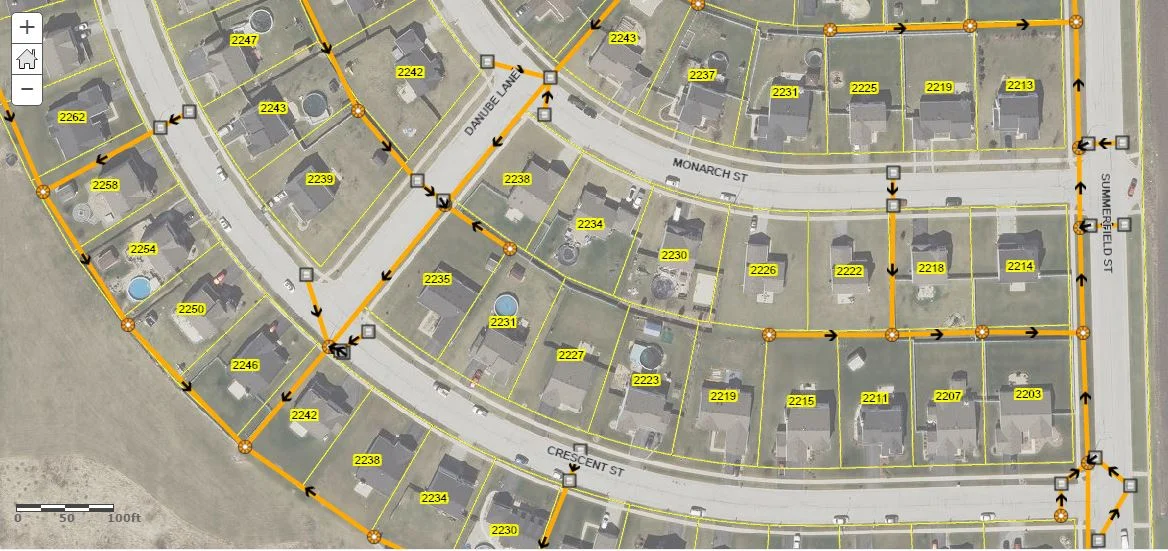
After a few years now of ArcGIS Online, there is still no support for non-simple line symbols. This means for utilities, or streams, routes or whatever line features you may be managing, you cannot easily display them with flow direction arrows as in Desktop. Please Note: Those with access to ArcGIS for Server can certainly publish map services that will support this type of symbology and can be displayed through ArcGIS Online. However there are probably many that do not have that option, so in this post I'll discuss a one method as a work-around to solve this...
Top 5 Geospatial Tips For your next vacation

This is a great website for planning your route and your stops. It has an excellent interactive map that allows the user to turn on and off layers including, hotels, restaurants, campgrounds, points of interest, natural wonders, parks, gardens, and more. It tallies your total mileage, travel time and includes an estimate for fuel expenses that updates as you alter your route. Depending on what your interests are, just turn on the layers and you'll be sure not to miss anything along the way.
Extend your Apps with Custom Widgets in Web AppBuilder

Cloudpoint has successfully upgraded a number of Flex mapping applications to Javascript applications in the past year using Web AppBuilder (WAB). Some of the components that make these apps stand out are widgets that improve the user experience with the app. . Esri packages a number of basic widgets in WAB, but some developers have designed custom widgets that extend the functionality of these applications. A number of these custom widgets were available in the Flex apps and we wanted to honor our client's wishes to provide the same tools and functionality. Here we highlight a few of the custom widgets we configured for our clients.
Leaving a legacy: Preventing the loss of Tribal Data.

As employees accumulate years on the job, they begin to build up an internal database of information. A common term for this is Tribal Knowledge. Tribal knowledge is used to describe the wealth of data that a long time employee has developed, obsorbed, and retained over time. This is a fantastic resource for your organization which can....
The more things change, the more they stay the same

I have installed production ArcGIS Server systems over a dozen times (rough estimate not counting upgrades) at different locations and under different IT environments. It is a world of change from the old ArcIMS days and so much easier. No Apache Server, no Tomcat, no enabling user permissions to make changes to the environmental variables or setting the %JAVA_HOME variable (How many times did a Java update break our sites? Ugh!). That being said each install has its own idiosyncrasies and challenges...
3 Reasons for Trying Workforce

5 Steps to Create a Multilayer Basemap

A multilayer basemap is a new feature that Esri rolled out in the March 2016 update of ArcGIS Online. Here are 5 steps you can take to create a multilayer basemap for your ArcGIS Online organization.
10 ways to use GIS for Sidewalk and ADA Compliance

Harnessing the power of Esri's Collector App

All of Illinois Geocaches in One Map*

I work for a living, but in the off times I still play with this technology, so I have a Premium Geocaching subscription. This allows me to query their data in circular buffers and return a GPX file. After about 27 of these queries, I was confident that I had all of the cache locations I wanted. Running a few geoprocessing functions, I dropped any duplicates and union-ed these points to county polygons to get the number within each county. This data are reflected in the Classified inset map. What am I talking about? Geocaching of course. If you're reading this tech blog there's a pretty good chance you already know what geocaching is...
Contours
Contours are a great way to quickly view an area and get the feel for the lay of the land. And the better the source data, the more you can do with them, from reference to planning. Recently we used data derived from LiDAR to build a county-wide contour layer. The reason we went with LiDAR data is that the accuracy is usually much tighter (and more recent) than existing elevation information.

Contours created from LiDAR derived data
There are obviously different methods and tools to do this but here in Illinois we are fortunate; ISGS has done a fantastic job of working with counties and vendors to acquire LiDAR data, then process it and share it with the public through the Illinois Height Modernization Program. For GIS users the available data even includes prepared ArcMap documents with layers derived from classified LiDAR. Very nice. So with this information and some help from ESRI’s Contour raster function and Spatial Analyst, as long as processing power and disk space are available, you can build and fine-tune contours for fairly large areas.
It should be noted that LiDAR and elevation data can get pretty large in terms of storage space needed, not to mention any downloading or transferring of files. And you may find if working with larger areas, that processing data in parts or sections at time is necessary due to software limitations or time constraints. These things may pose challenges, to find the right fit for your needs and workflow(s). Overall however, this has been a great example of where open data meets ever-improving technology.
