
Ever wonder if that route you run every day is the most efficient? Looking back, it all started when you found a map, grabbed your highlighter, marked it up and Voilà! From that day forth, your agency's routes were set in stone and they've been traveled over and over and over again ever since. You know that route like the back of your hand and of course its the most efficient because after all, you came up with it!
Well now with GIS tools such as ArcGIS Network Analyst for optimizing routes with the Vehicle Routing Problem Solver you may find that your old highlighted map is costing you lots of money in wasted fuel, time, and equipment ware. This post will take a brief look at the process optimizing routes for solid waste and recycle collection.
Step 1. Obtain point features for pickup locations

Garbage or recycle bins are located with GPS or geocoding methods and loaded into the GIS as point features to represent the various stops along routes. In this case the pickup locations were condensed to one point per street segment to allow for more efficient processing within the ArcGIS Desktop software.
Step 2. Generate Orders for Routing (condense if needed)

Creating optimized routes for thousands of pickups can take a considerable amount of time to process even with the latest hardware. For this example we used GP tools such as Create Route Event Layer and Generate Near Table to condense points along road segments and determine right or left side of street. This also allows for the pickup quantity field in the Orders class to be used as the number of cans along that side of the street. During this phase you will also place your 'depots' (starting and ending locations, including renewal locations such as landfills) on the map.
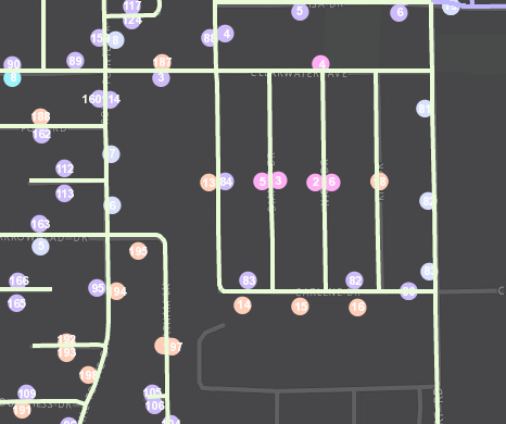
Step 3. Model Existing Collection Routes

By creating models of the existing collection routes within the GIS, we can confirm that variables such as travel times and service times are actually giving us "real-world" conditions and will provide credible results in our proposed routing models. Here we can see that the existing routes are very "block-like" and cleanly divided by neighborhood or subdivision. Looks pretty but not necessarily 'optimized'.
Step 4. Adjust Orders (pickup locations)
You may need to manually adjust some order locations and attributes as a result of modeling the existing routes to make sure the data is accurate and providing expected results with proper sequence of stops for the given route.
Step 5. Evaluate Various Scenarios and Select Optimized Routes

When processing the new routes, select various scenarios and compare those results to the existing routes to identify cost savings. For example, if the current collection program is running seven (7) trucks, try running a proposed model with only six (6) trucks and compare results. Cost saving measures are usually identified by total time or total distance. Once optimal routes have been selected, you will want to drive those routes as a quality assurance measure to be sure they are modeled accurately from the provided street network data.
Step 6. Using the Results
ArcGIS Network Analyst can generate turn-by-turn directions with detailed information on stops and estimated arrival and departure times. This information can be distributed to the drivers or entered into a GPS guidance applications such as Navigator for ArcGIS which will soon allow users to utilize their own pre-defined routes from ArcGIS Desktop or Online.
