Recently Cloudpoint completed a drone flight of Roanoke, IL. The mighty burg of Roanoke is home to Cloudpoint HQ and often times is our guinea pig for implementing or testing new services. We set out to fly all of the town and capture detailed, crisp, clear imagery with our drone mapping capabilities. Although some of you instantly understand what a benefit this can be for a municipality, we thought it may be helpful to talk about the advantages to having Cloudpoint complete an aerial photography flight for your organization.

Here you can see the difference between the standard imagery basemap from Esri on the left and from Cloudpoint Aerial Services on the right. The updated imagery can assist in inspecting hard to reach areas like roofs and water towers.
First of all, the most important benefit is the amazingly detailed imagery that is collected. Below you can see a side by side comparison between standard Esri ArcGIS imagery and the images that we collected. The difference is clear.
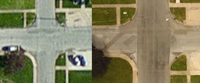
Here is another side by side comparison between Esri's base imagery on the left and the imagery collected by Cloudpoint's drone. While the left image is pretty blurry, the updated imagery allows you to see inlets, road patching areas and much more detail.
In addition to providing superior imagery, the timeline for deliverables is another plus for having Cloudpoint complete a flight of your city. Since we handle every step of the process in house, you can get your imagery brought into your GIS in days instead of months. With the ability to track projects from the sky, compare new and old imagery to look for unapproved parcel improvements which generates revenue, and the ability to locate manholes, valves, and inlets, a town-wide drone flight is a powerful tool for enhancing your GIS and mapping.
Click here to view the Roanoke 2017 Ortho webmap
Although Cloudpoint can fly yearround, the best times for getting imagery is in the Fall after the leaves come down or in the early Spring after the snow melts and before vegetation starts to grow.
If you have any questions, please contact us at 877-377-8124 or you can visit www.cloudpointgeo.com/drones
