top of page


Methods for Creating Indoor GIS Floor Plans
How to migrate CAD, BIM, PDF, and LiDAR-scanned building floor plans into ArcGIS Indoors. Cloudpoint's guide to indoor mapping and CAD-to-GIS conversion methods.


Federal COPS School Violence Prevention Grants Announced for FY2026
The U.S. Department of Justice (DOJ) Community Oriented Policing Services (COPS) Office has officially released the funding guidelines for the FY2026 School Violence Prevention Program (SVPP) (Opportunity Number: O-COPS-2026-172540). There is up to $73 million available nationally for school districts and local governments to fund school safety technology, infrastructure, and mapping projects, with a final submission deadline of August 11th, 2026 (Step 1 via Grants.gov is due


Hooked on Geospatial. Welcoming Dillon to Cloudpoint!
We're excited to welcome Dillon to the team as our newest GIS Technician. Dillon hails from West Central Illinois, near Macomb. He recently graduated from Illinois State University with a Bachelor of Science degree in Environmental Systems Science and Sustainability, alongside minors in Geography, Biology, and Water Sustainability.

How the University of Notre Dame Transformed Campus Operations with ArcGIS Indoors
The University of Notre Dame manages more than 11.5 million square feet of building space across 200+ buildings on 10 global campuses spanning 5 countries.
In October 2024, the University Facilities Information Department (UFI) initiated a migration of its indoor mapping, space planning, and asset mapping operations from the legacy Cartegraph InVision system to Esri’s ArcGIS Indoors.


How to Create a Custom ArcGIS Python Assistant in ChatGPT
Organizations that rely on ArcGIS often spend significant time writing, troubleshooting, and maintaining Python scripts. Whether the task involves automating geoprocessing workflows, managing hosted feature layers, cleaning attribute data, or building Python GIS automation tools, developers frequently reference the same documentation and follow the same coding standards.


The Strategic Evolution from ArcGIS Online to ArcGIS Enterprise
ArcGIS Online often serves as the initial foundation for GIS, and for good reason. Maps stay live, dashboards provide consistent insights, and the burden of server maintenance remains entirely off the table. However, as an organization matures, a recurring question eventually surfaces: Is it time to transition to ArcGIS Enterprise?


Streamlining Indoor Mapping: Direct CAD to GIS Conversion in the Browser
CAD-to-GIS conversions are notoriously complex and time-consuming, requiring manual data preparation and standardization prior to migration. Because of this, Esri has developed a variety of methods to streamline the process of getting floor plan data into ArcGIS Indoors. This article explores these options and highlights the advantages of each approach. This article explores these options and highlights the advantages of each approach.


Staying Sharp: Welcoming Savannah to the Business Development Team
Savannah Sharp has recently joined the Cloudpoint team as Business Development Technician. She will help our team expand our market footprint across all industries with targeted outreach and marketing.


Driving Decarbonization: Automating Student and Employee Travel Time and Distance Calculations for the University of Colorado Boulder
Project: Origin-Destination (OD) Cost Analysis Automation Tool
Client: University of Colorado Boulder (UCB) Sustainable Transportation Team


Breaking Down Data Silos: How Facility Technology Modernization (FTM) turns Buildings into Smart Campuses
For many facility management teams, responding to work orders involves logging into various maintenance portals, looking up asset information in spreadsheets or database records, searching a shared drive for floor plans as PDFs or CAD files, and dispatching a technician to locate the correct access panel. In many situations, the technician may not have access to the asset records in the field, requiring additional office work upon their return. In modern commercial, healthca


Fast Track to ArcGIS Pro: A Guide for ArcMap Users
ArcMap was officially retired on March 1, 2026, meaning it is no longer supported by Esri.
The good news? ArcGIS Pro is not just a replacement. It's better, faster, and significantly more stable than ArcMap. For those hesitant to make the switch, this guide offers a fast way to get comfortable.


Tackle Your To-Do List with ArcGIS Field Maps
Managing fieldwork can mean juggling spreadsheets, emails, and phone calls just to keep track of what needs to be done. Fortunately, Esri has added task capabilities to ArcGIS Field Maps, providing a simple way to create, assign, and manage fieldwork directly within your ArcGIS environment.


Tazewell County ETSB Advances Landmark School Safety Initiative
TAZEWELL COUNTY, IL - Tazewell County Emergency Telephone System Board (ETSB) is nearing completion of a comprehensive countywide initiative to map the interiors of all K-12 facilities, providing first responders with unprecedented wall-to-wall visibility. Leveraging the Illinois NG9-1-1 grant for public school buildings, the county has nearly completed mapping of all public schools. With the final public school and a planned expansion into private facilities slated for compl


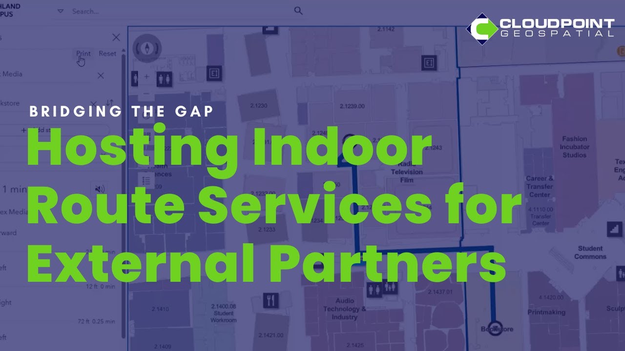
How Cloudpoint Geospatial Supported Enhanced Indoor Routing at Austin Community College
ACC partnered with Cloudpoint Geospatial. As an experienced Esri Gold Partner, Cloudpoint provided the missing link by hosting ACC's network datasets within our own, secure ArcGIS Enterprise environment in Amazon Web Services (AWS).


New Year, New (ish) Faces
We're starting off the year welcoming two new employees to the team! Seth Stark is joining us as Local Government Team Lead for the Eastern US. Those in the Illinois GIS Community will recognize Seth! Having previously served the City of Decatur for over 13 years and the City of Garden Grove, California, for 5 years, he is not new to the GIS scene.
bottom of page