Esri Community Map Program - Providing Feedback on Basemaps
- Dec 6, 2021
- 3 min read
In 2010, ESRI started the Community Maps Program with the goal of enhancing and updating their foundational basemap layers with current and detailed local data. Over a decade later, tens of thousands of updates have been made using the tools available from the program. By contributing data, the community itself benefits from having local knowledge input directly into ESRI maps. This additional data helps power advanced analysis and can be used to create in-depth story maps.
Apart from the direct use of updating basemaps, this collection of local data also helps to enhance and power the ArcGIS Living Atlas layers.
There are three different ways to contribute to ESRI’s Community Map Program. The first way is through the Provide Feedback option, and will be the topic that this blog covers. The Community Maps program also offers an online feature editor to digitize and make manual changes to basemap data. When updating basemaps through this Edit Features option, ESRI will review the suggested changes once submitted. Additionally, data can be packaged up and shared with ESRI.
This Share Data option requires data to be standardized in the Community Maps program format and tends to be used when sharing a mass amount of data.

Updating a map through Providing Feedback requires very specific corrections to be made on what is seen in the map. After clicking the ‘Provide Feedback’ bubble, the next page requires the user to select one of three maps to provide feedback on. The webpage will list a description of the intended use of each map, but a summary follows:
1. Use the ‘Geocoding Feedback’ map to mark errors and suggest corrections for addresses.
2. Use the ‘ESRI Basemap Feedback’ map to mark errors and suggest corrections for any data displayed in the standard ESRI basemap offerings.
3. Use the ‘Imagery Map Feedback’ map to mark areas with bad imagery.


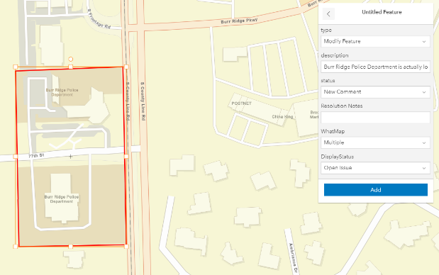
After clicking on the ‘ESRI Basemap Feedback’ map, review the instructions that the next webpage displays then select ‘Open in Map Viewer’ on the right side of the screen. This will open the ESRI ‘Basemap Feedback Map’ in the new map viewer. Zoom to the area where you would like to suggest the change, select the edit tool in the bottom right, and ‘Add Feature’ over the specific spot needing the change. After creating the polygon, fill out some details in the map pop-up to provide additional information on why the change is being requested. Finally, select ‘Add’ to save the feature to the map. This new feature will then be added to a list to be eventually reviewed by ESRI.

Some important things to note in this process are the duration it takes to approve the change as well as the accuracy of the details provided in the pop-up. ESRI states that it takes 4-6 weeks to approve suggested changes pulled from the ‘Provide Feedback’ maps. In our previous work, we found that the basemaps were updated around 5 weeks after the feedback was submitted. It is also important to make sure that the additional information is detailed enough to capture all changes you would like reflected. For example, in the basemap edit request there are multiple basemaps that you can request the update to be reflected on. You must specify which ones you would like updated, and in some cases, specify multiple to completely fix the error.


