top of page


Asset Management in ArcGIS Online
How do you feel when you hear the term “Asset Management”? Is it just the (latest) buzzword for what you’re already doing? On your...


A How to Guide: Performing a Valve Isolation Trace in the ArcGIS Utility Network
The ArcGIS Utility Network’s functionalities are endless. Although it can seem a bit daunting to start using the Utility Network, we are...


Missing Addresses
Time is critical in the Emergency Response profession. The accuracy of data allows speed and clear communication. For this reason, the...


Spruce Up Your Survey123 Skills: Part 1
Survey123 Connect offers an array of ways to create powerful and customized forms for collecting data, but learning how to use some of...


Highways and GIS: Having the Right Tools for the Job - Permitting and Automation
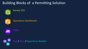
As technology continues to grow and evolve, so should our workflows. Traditionally, permitting involved a paper form that was provided to...


The Role of GIS in NG9-1-1 and EMA
Next Generation 9-1-1 (NG9-1-1) is a technology upgrade to the traditional 9-1-1 emergency response system. It aims to improve the speed...


Building and Maintaining a Fiber Optic Network Using GIS and ArcGIS Online
There are thousands of Internet Service Providers (ISP’s) scattered across the U.S. A quick Google search will provide you with a broad...


Top 5 Reasons to Move to ArcGIS Pro in 2023
Looking for some new professional goals for the new year? If you’ve not yet made the move to ArcGIS Pro from ArcMap, may I suggest that...


5 Steps to Build a Facilities Space Planning Dashboard Using ArcGIS
Space planning and management is an important part of any college campus or school district. It helps facility managers ensure that they...


NG9-1-1: Tips for Synchronizing Border Data
Coordination with surrounding PSAP territories allows dispatch redundancy and compounds the effectiveness of Next Generation 9-1-1 by...


Find Your Bearings: 5 Steps for Creating Subdivisions in ArcGIS Pro Parcel Fabric
Are you new to the ArcGIS Pro Parcel Fabric and want to map subdivisions? Find your bearings here with these 5 easy steps. 1. Review...


Using GIS & LIDAR to Conduct an ADA Site Assessment
ADA compliance is a big issue these days, with many agencies struggling to find resources to address their compliance issues. First and...


No GIS? No Problem!
What is stopping you from accurately locating all of your assets in the field and using that information to make informed, data driven...


Using GIS for Campus Facilities: Organizing Digital Floorplans and As-Built Drawings
When setting out to use GIS for Campus or Facility management, it is important to understand what type of data tracking challenges are...


Tracing a Path from the Utility Network to Experience Builder
The following videos will walk you through creating and saving trace configurations, publishing them in a web map, and consuming them in...


Digitizing Floor Plans for Indoor Data Space Management
Space is expensive. Due to this simple truth, it is important to ensure the accurate digitizing of features and space inside your...


Better Together: Collecting GIS Data with Trimble Catalyst GNSS and ArcGIS Online
Trimble is a global leader in positioning technology and Esri is a best-in-class geospatial software provider. When these two powerhouses...


Deciphering the NG9-1-1 Tea Leaves for GIS Components and Timelines
April is Emergency Communications Month . Cloudpoint recognizes the often unacknowledged critical public service our nation's emergency...


A New Branch on the Versioning Tree: An Overview of Branch Versioning
Excerpt Enterprise geodatabase versioning is an integral part of Enterprise GIS workflows and allows for flexible and manageable...


Get the Lead Out: Lead Service Line Replacement and Notification Act
Illinois passed the Lead Service Line Replacement and Notification Act in May of 2021, and it went into effect January 1, 2022. The...
bottom of page