ArcGIS Online

To Portal? or not to Portal?

No, not the game Portal. ArcGIS Portal

Last year Esri released Portal with ArcGIS Server as a free extension. There has been a fair amount of confusion surrounding the product. What is it? Should we install it? What is it? 

One things is for sure; Esri keeps talking about Portal (or at least "a portal") so it must be important, right? Part of the confusion comes with issues of terminology. Another is people being unwilling or unable to explain the difference or what clients should do. I want to help with both. 

If you're a Esri shop, ArcGIS Online (AGO) is the platform through which all your GIS will be pushed out to your customers and users. If it isn't now it will be, so go ahead and relent. That platform is a portal (lowercase 'P'). To induce this platform acceptance, Esri decided to giveaway the server-software that runs ArcGIS Online. That is ArcGIS Portal (Capital 'P').  So you're using a portal when you are using ArcGIS Online and you're using a portal when you are using ArcGIS Portal. Get it? 


Now, Should you install and use ArcGIS Server Portal Extension? Probably not. Just use ArcGIS Online. Here's a quick Frequently Asked Questions when is comes to campaign ArcGIS Online (AGO) v. ArcGIS Portal (Portal)


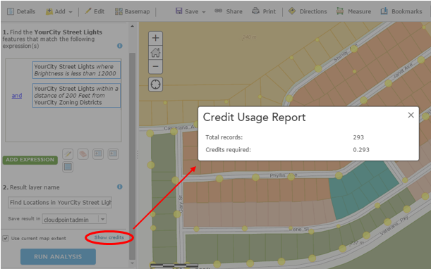
Q: What about credits?  STOP WHINING ABOUT CREDITS, THEY'RE CHEAP!
Q: What about Security? AGO is highly secure by default, probably more secure than your ArcGIS Server installation, which has No security by default BTW. 
Q: Will AGO work with local services running behind my firewall? Yup. 
Q: I don't like my data being hosted on AGO. So don't. the idea of a portal is a window, not a dropbox. 
Q: Do I have complete control over my content? Yup. 
Q: Can the Portal software run on my existing ArcGIS Server? Maybe, but it shouldn't. Are you asking to overload Your PrintServer/FileServer and make it an ArcGIS server too? Recommended Best Practice is to run it on a separate server by itself. 
Q: Will AGO Work without the internet? Ok. Got me there, No. Your users do have to have access to the internet and most subdomains on arcgis.com. So you will have to whitelist a fair number of URLs. Whereas portal can completely be on your internal network. Sequestered. 
Q: If I'm offline, how does Portal get updates to the basemaps? You install them.  
Q: Then how about new tools that are release on ArcGIS Online? You Install those too. 
Q: What about other peoples shared data outside my organization? No Workie.
Q: What if, I am using  Portal and I want to upgrade my hardware to meet customer demands? You cancel your weekend plans. 
Q: Seriously, What real benefit to I get from installing Portal? Your own Domain, Hyper-active-Internal-I.T.-Caveman-Security, Lots of extra work and a reason to spend lots of money on infrastructure hardware, bandwidth & overtime. 

A Portal is a place for connections, like an airport

The security thing could be a genuine issue ... for like the Department of Defense. If you are in local government IT, it really isn't a deal breaker. Does Your server have Multi-Factor Authentication? ArcGIS Online is pretty seamless with ArcGIS Server and plus wouldn't you rather offload some of your bandwidth? In most cases (95%) with city/county government ArcGIS Online will most always meet the orginization's needs.

Not So Lite Anymore

For the first few years, ArcGIS Online was considered ArcGIS-Lite by many of us (including me). Pushing data to the cloud without the need for a server was indeed huge, but capabilities were often not. Even down to the lack of labeling, it was almost extremely basic in many respects. However, those of us who have been using and following the platform have been impressed by the gusto with which ESRI has pursued the enhancement of ArcGIS Online.

Over the last couple of years we’ve seen improvements across the board, from symbology to data storage, from basemaps to analytical capabilities. For instance, data collectors can now take data offline where internet access is limited and sync up when convenient. Or how about related tables - editing related records via the Collector app is finally here. FINALLY. And that’s not to mention the continued improvement to web application templates (there are 24 now, and that’s not including Web AppBuilder) that require zero coding to setup. Even the help documentation is pretty fantastic these days.

So there’s A LOT to be excited about in the world of ArcGIS Online. But right now I’d like to focus that excitement on spatial analysis. You know, that fun stuff that got so many of us intrigued by GIS, but so few of us utilize in the real world. Well ArcGIS Online has had improvements to that side of things to. So what kinds of situations would you find spatial analysis useful? Maybe you’re unfamiliar with the concepts, or maybe it’s just been a while. So here are a few examples:

Proximity and Site Selection

    Displaying areas or features within a specified distance from main roads

    Displaying areas or features within a specified distance from a flood plain

    Finding location(s) within an area containing a certain threshold of elderly population

    Finding location(s) within an area containing a certain threshold of young professionals

    Where can food trucks station based on local rules and regulations

    Combinations of any two or more sets of parameters or specs

Analyzing Patterns

    Determining areas with a high or low density of grocery stores

    High and low clustering (Hot Spot Analysis) of owner-occupied land parcels

These are just a very small sample of uses. Using GIS to perform analysis adds the visual component to the results, or an extra dimension in terms of data. It not only looks cool, it helps with comprehension!


Completely Fictitious Example Workflow

Let's say YourCity is interested in determining dimly-lit residential areas to allocate resources to. There have been a number of complaints and safety concerns, and now there is some funding available. So it is up to you as the GIS professional to assist using GIS as a tool to find and display the best areas to allot that funding.

In this case you are using zoning and streetlight information made available to you.

Step 1: Display Streetlights by Brightness Values

Symbols Sizes by Brightness and Classified by Natural Breaks

Light Symbols by Brightness

Step 2: Determine Residential Areas

Filter zoning layer to only display designated residential areas:

Step 3: Find Existing Locations

Use Find Existing Locations tool to determine where streetlights falling below a brightness threshold are near residential-zoned areas. This will use both an attribute query and a spatial query to produce a new layer meeting the specified criteria.

Step 4: Review Results

Find Existing Locations Results.png

In this small, controlled area it is apparent and obvious where the targeted data fall. However in a larger area, it would be useful to further analyze these results to determine where clusters of dimly-lit areas are located. Those results could in turn aid in the decision making process regarding resource allocation.

Disclaimer: Two things you should always keep in mind - the quality and completeness of the input data, and choosing the appropriate boundary for your analysis, as changing the analysis extent will change your results.


Q: I have desktop. So why perform the analysis on ArcGIS Online? A: The same reasons that you use ArcGIS Online for anything – you can easily share the data through the web. You can dress it up in an application or presentation. And access it anywhere.

Q: What about service credits? A: No worries. First of all it’s not as bad as you might think. Second, you have a chance to see how many credits you will use before you pull the trigger. If it’s too much, you can back off or change your processing extent – but you’ll be surprised at how reasonable it is.

Anticipated credit usage can be reviewed before performing analysis


So there you go. Check it out, or ask someone who has. The spatial analysis capability with ArcGIS Online is here, it’s a great tool - and like the rest of the platform is constantly improving. Look for ways to answer your questions with GIS and add that spatial component that you can visualize and share.