Cloudpoint Geographics has a commercial!

Do you ever have problems explaining what GIS is? Or maybe your Mother-in-Law still doesn't know how to explain your job to her knitting circle. We at Cloudpoint understand and can help with that as well. Recently, Seth Hodel (No relation to Jon) helped put what we 'Do' and the concept of GIS into a short video.

Enjoy and share.

Thanks to the City of Fairbury for permission.

Cloudpoint Joins the Esri Business Parnter Network

The Staff at Cloudpoint Geographics Inc, is pleased to announce that we are now a part of the Esri Business Partner Network! 

,The Esri Partner Network is a worldwide community of companies that develop and deliver cutting-edge geographic spatial solutions and services based on Esri technology. Together, Esri and its partners collaborate to support end users through successful GIS implementations and repeatable solutions.

With this partnership, Cloudpoint will have continuing access to the latest Esri software and ideas to benefit our customers. This notch in our belt is just another example of our desire to succeed and stand out as the go-to geospatial consultant in the Central Illinois region. 

If you have any questions or want to know more about this exciting opportunity. Contact Us

About Cloudpoint:

Cloudpoint is a dynamic geospatial solutions provider specializing in Geographic Information Systems (GIS) consulting for a wide range of geospatial needs and services. These needs could include mapping, GPS data collection, field inventories, utility mapping, land & parcel management, and GIS consultation for state & local governments, transportation agencies, utility companies, engineers, surveyors, contractors, facility and land managers.

About ESRI:

Founded in 1969, ESRI (www.esri.com) is the world leader in the GIS software industry. ESRI offers innovative solutions that help users create, manage, analyze, and display information to make timely decisions and solve problems they encounter every day. ESRI’s comprehensive product line ranges from desktop GIS to GIS for the enterprise.

Happy Thanksgiving

Happy Thanksgiving to all! As we celebrate what we are thankful for, Cloudpoint Staff looks at what has blessed them and lead to such a great first year. From new technology to a new website we have certainly found our place. 

Website - Cloudpoint just updated their website to offer client based viewing solutions. The website has a different look and has industry white papers by our staff as well as our statement of qualifications and brochure. The client based solutions offers a viewing application to show assets and attributes that have been added. Online editing applications are to come.

Bathymetric Mapping - FINALLY! After some research, development, and programming, we have created a bathymetric mapping solution for lakes and lagoons. Connecting a sonar unit to our Trimble GeoXH, Cloudpoint has a cost effective solution for mapping lake bottom features and contours.

Data Collection - Recent projects have proven the use of GIS to municipalities. The City of Fairbury, Illinois knew of a few hundred surface sewer and water features, but after data collection with the workers in the field, we found ourself collecting well over 4,000. The use of sub-inch GPS and the help of the sewer and water department employees ensures the best collection of attribute data and a complete GIS system. Collecting this CMOM data now ensures that municipalities will know where there assets are for the next generation of employees.

LIDAR - Matt Dondanville, our second employee, has taken the role of LIDAR expert. Taking grad school classes to explore the best processing techniques, he has found interest in aerial and mobile applications for local government. This technology is the future of geospatial services for municipalities and Cloudpoint strives to be on the cutting edge.

As Cloudpoint grows and continues to learn. We find ourselves being thankful for what we have been blessed with. We hope everyone had a great Thanksgiving and hope to hear about your successes.

Getting beyond the electric fence with a Trimble Geo XH...

Avoiding the shock of the fence and the charge of the bull....

So how do you get a highly accurate GPS location on something that is not accessible???  Using the Trimble Geo XH 6000 series and Terrasync (cm) Edition we are able to use the "Offset" command in the Data collection tools within Terrasync software.  We simply tell the unit that the point is exactly 10 feet south of our current location and we start collecting data.  The system will automatically assign the GPS location with an offset of the given distance and bearing.  Out in the woods and not sure on the bearing??? Simply pull out your iphone and use a compass app to come within a couple degrees of the actual direction.  Keep in mind you will need to calibrate the app prior to using it but it is very simple to do.  In addition, remember that the farther away you are standing from your target, any error in the bearing will be greatly exaggerated so its generally good practice to keep the offset distance to a minimum.  For more tips and tricks on GPS data collection visit us at www.cloudpointgeo.com.

Visit us at www.cloudpointgeo.com

Look For Us at Upcoming Events! ILGISA, IACE, IPLSA, ILCMA

Cloudpoint Geographics is coming to a location near you...


Visit us at our New Display!

Here is a quick update on where we plan to be (the Lord and weather willing):

Sept 27, 2012- IACE (Illinois County Engineers Association)-

Bloomington, IL

October 16-17, 2012- ILGISA (Illinois GIS Association)- Naperville, ILNovember 5-8, 2012- Trimble Dimensions 2012- Las Vegas, NV

February 14-15- IPLSA (Illinois Professional Land Surveyors Association)-

Springfield, IL

February 20-22- ILCMA (

Illinois City / County Management Association

)- 

Peoria, IL

Be sure to stop by for a visit to find our more information on the following:

  • GPS inventories & asset management
  • GIS for Mobile Devices (including Androids & iOS)
  • ArcGIS products, extensions, & training
  • Trimble Mapping & GIS Product training
  • Web-hosted GIS solutions
  • LIDAR data collection & processing

Visit us at www.cloudpointgeo.com

Big Fish Tales!

Normally I only post every couple of weeks but this one couldn't wait.

Jon Hodel with a 33+ inch Northern Pike
42.490217, -85.426408

We went on our annual fishing trip with a great group of friends this past weekend and had some great success.  We hit the water as soon as we arrived on Thursday late afternoon and there was a front moving through that must have gotten these toothy critters excited.  The northern were explosively hitting almost anything we threw at them.  This one was caught on the SE corner of the large island in about 8 feet of water with lots of weeds on a Mepps No. 5 Aglia with red & yellow stem.  If you are patient enough to cast into the weedy areas and pull the "veggy tales" off your line, you can expect these guys to attack at any time.  Overall our group pulled in over 500 fish (blue gill, crappie, bass, and northern) and 8 of them that were over 30 inches in length.  Don't worry, we threw them all back except for a few pan fish so you can give it a try yourself.

So Where are Your Underground Utilities?

How do you find your underground utilities?  Does your method of relocating them consist of your veteran public works director and the third-generation local excavator estimating them based upon a combined 70 years of memory?  We find this all to common in today's communities where their baby-boom staff will soon retire and take with them an incredible amount of "tribal knowledge".  Although they may have an incredible ability to tell where those 50 year old lines are at, someday these folks will not be available.  That's why mapping these utilities with GPS equipment is so critical!  Don't loose all of that valuable information, you just can't take that risk.  It doesn't have to be expensive equipment that costs thousands of dollars.  Even a simple $200 Garmin eTrex will get you headed in the right direction.  Today's GPS equipment can provide accuracies that vary from five feet to five millimeters.In addition if you are a local government agency that has a permitting process for underground utilities, why not start requiring the permittee to provide you as-builts with GPS coordinates.  You can do this with a simple ordinance update and even specify the accuracy requirements, and they don't have to be overly tight.  This is not an unreasonable request and will not place an "undue" hardship on them when the cost of GPS equipment is so insignificant these days.  The point is once you have the data it can be used in so many different capacities.  So why not set your agency on the right course today and make things better for the next generation!

Visit us at www.cloudpointgeo.com

Former County Employees teaming up!

Micah Williamson, the current GIS Manager for Peoria County recently announced he will be leaving his current post to join former Woodford County employee, Jonathan Hodel, at Cloudpoint Geographics, a geospatial services company located in Roanoke, IL.  Hodel resigned from the Woodford County Engineer position last year to pursue his life-long desire of starting a geospatial engineering company, utilizing the latest technology in mapping and remote sensing for geogaphic information systems (GIS).  Hodel says, "Micah's talents and outgoing personality make him a perfect fit for our team.  He has a great ability to help the layperson understand new technologies and how they can benefit from them."

Williamson, a resident of Eureka, IL has held the GIS manager position at Peoria County for more than five years and will continue there on a part-time basis until a replacement is found. Prior to working for the County, Williamson worked as the GIS Analyst for the Greater Peoria Sanitary District and has also taught GIS classes at Illinois Central College and Geography at Eureka College.  He will join a staff of three employees at the young and growing company.

Micah Williamson, Peoria County GIS Manager

Visit us at www.cloudpointgeo.com

Where is rain most needed? 2012 Illinois Drought Map

Here is a recent map of the severity of the current drought in Illinois.  This map shows the lack of rainfall throughout the state for the month of June.  We are currently obtaining additional data for the entire summer that will provide greater insight as to the hardest hit areas.  Contact us for more details!

Visit us at www.cloudpointgeo.com

Hard at Work!

Here is a snapshot of Matt and myself at our office in downtown Roanoke working hard on our latest GIS projects.  We have been keeping busy with mapping water main, sewers, and a lot of fiber optic lines.  We also have an exciting geospatial application in the works involving LiDAR that we hope to release more information about later this year.  Stay tuned here at our blog to receive updates and please sign up to subscribe if you have not already done so.  We promise not to bore you or overload you with junk emails!Take care!

Introducing Cloudpoint's latest edition!

Cloudpoint Geographics is pleased to announce the hiring of Matthew Dondanville to the position of GIS Technician!  Matt will be filling an important role in performing GPS mapping and data collection and providing client services involving GIS training and consultation.  He comes as a highly regarded graduate from Grand Valley State University in Allendale, MI with strong technical skills involving CAD and GIS applications.  Matt plans to pursue a Master's degree in GIS through the online program at Penn State University and his GISP certificate soon thereafter.  Welcome aboard Matt!Stay connected with Matt: Cloudpoint is always looking for talented people.  Send your resume to jhodel@cloudpointgeo.com if you are interested in joining our team!

Visit us at www.cloudpointgeo.com

Sign Inventories: Five Lessons Learned!

Cloudpoint Geographics

has performed many

GIS data collection projects

so far and here are some of the valuable lessons learned from completing this work:

Sign Inventory snapshot from Concord Township in Bureau County, IL

1

.

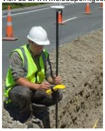
Get the data when you're there

.

  Be thorough when in the field.  All too often we come back to the office and wish we had collected more information or question one of the sign attributes.  If we take the extra minute or two when out in the field it gives us the best end result and complete inventory.  This is one reason that mobile mapping is becoming so popular.  You bring much more data back to the office and can post process so much more... eliminating mistakes and questions including saving time and money from repeated site visits.

2.

More data is not always better.

When it comes to feature attributes for GIS work, people can come up with some craze ones... color of sign post, angle of the leaning post, type of hardware.. and the list goes on.  Let's be realistic about it.  Is this necessary for our inventory and are we really going to maintain all of this information?  Focus on what information will be used in the initial inventory and what will be maintained upon future inspections.

3.

One person, start-to-finish.

It's important for one person to be responsible for collecting data and that same person for assembling the inventory.  Often times a question comes up that only the person doing the field work will remember.  This makes it of critical importance that the same person be responsible for completing the final product.

4.

Begin maintaining your inventory immediately.

Don't let collected data sit on the shelf too long.  For one, it helps with the issues described in #3, and it also allows for maintenance of the sign inventory to begin sooner.  If you complete an inventory and don't begin maintaining it for several months, by the time you get started it is outdated and you have a lot of work to get caught up.

5.

Be creative with data collection.

It is important to be creative with data collection.  You want to work quickly and efficiently when collecting GIS data and this does not always equate to one out-of-the-box solution or software program.  At times it may be best to use a mapping software program to collect feature locations and a spreadsheet program to collect data on those features.  Other things to consider is how to quickly collect data in the field.  Don't rule out ideas such as voice recognition on smart phones or dictation to later be inscribed by other staff back in the office.

There are many things to consider when working on data collection projects, large and small, but most importantly is to remember that proper planning is the key to a successful project.  

Those who fail to plan will plan to fail.  

Written By: Jonathan J. Hodel, P.E.

Visit us at www.cloudpointgeo.com

Cloudpoint acquires ArcGIS Server 10.....

We have recently signed up for an

AWS (Amazon Web Services)

account and setup

ArcGIS Server on an EC2 instance

.  To describe it in non-technical terms, we are using Amazon Web Services as a "server" instead of buying our own.  It's not only less direct overhead but also allows for scalability (only use what we need).  To learn more about this visit the

AWS website

.  This means Cloudpoint will be looking to offer a way for our clients to follow the progress of their mapping projects live and up-to-date as they are being completed.  It will also allow us to build some customized applications and have a method for field testing them before deployment.  Many of our clients are looking for ways to better manage their infrastructure and utility assets by way of a centralized GIS and we are working hard to bring the right solutions at an affordable price.  Also we have been telling you about our new website and new look that will be rolling out this summer.  Here is a sneak peak at our new logo...

Visit us at www.cloudpointgeo.com

Cloudpoint selected for fiber contract!

Cass Communications

has contracted with Cloudpoint Geographics to complete utility mapping of its fiber optic network.  The project consist of gps data collection of the utility's fiber optic lines and infrastructure over a 13 county area.  The collected data will be used to implement a GIS system that will help the utility manage it's fiber network more efficiently.

CASSCOMM is comprised of many different companies specializing in the telecommunications industry. Based out of central Illinois and serving thirteen counties with the latest in technology, CASSCOMM operates Cass Communications Management Incorporated, Cass Cable TV, Cass Internet, Cass Telephone, Cass Long Distance, Cass Advertising and Greene County Partners offering services including: cable television, high-speed internet, digital phone, landline telephone service and cable television advertising.

Visit us at www.cloudpointgeo.com

The Blizzard of 2012!!!

LAST YEAR'S WINTER SEASON!

THIS YEAR'S WINTER SEASON!

Spring is just around the corner and it appears that we may be finishing one of the mildest winter season's on record.  If your snow removal budget is in great shape and you are looking how to best allocate those savings,  why not look at what

Cloudpoint Geographics

has to offer you.  Now is the perfect opportunity to upgrade your sign or culvert inventory, complete that town-wide water main mapping project, or explore how LiDAR can help with your next reconstruction project.  Whatever the case, Cloudpoint's engineering and GIS expertise can get you headed in the right direction.

Visit us at www.cloudpointgeo.com

Do You Know Your Retro???

OK, so the time has come for agencies that currently maintain traffic signs to have a management method in place so that you can maintain minimum reflectivity of your sign panels.  If you have not already started your inventory or if it consists of chicken scratches on a vendor-supplied notepad that you picked up at your last conference.... never fear.  Cloudpoint Geographics, Inc has completed several local agency sign inventories and has the professional experience to provide you with a thorough and complete package.  We come to your site and perform a complete analysis of your current traffic signs including information on the following:

  • A complete field inventory of existing signs currently under city jurisdiction using GPS assisted data collection with ESRI ArcMap and ArcPad GIS software
  • Summary of all signs including ID number, quantity, street name, description, MUTCD code, size, support type, sheeting type, height, & width.
  • A map book (color, 11x17, bound with hard cover) identifying each of the sign locations with the corresponding ID number (click here to see a sample inventory)
  • A full report including recommendations for improving the safety and efficiency of your agency's roadway/street network.
  • A recommended sign inventory management method as required by the MUTCD

Contact us today for a free consultation regarding your agency's existing sign inventory!


A New Year, A New Face, and New Opportunities

Here at Cloudpoint Geographics we have started the new year off with a bang! We hired our first employee, Hannah Sauder. She is taking on the role of administrative assistant. It will be great to have an extra hand in the office as we begin to take on more jobs.Speaking of more jobs, we are busy writing proposals and are looking for a GIS Mapping Technician to join our team!
We here at Cloudpoint Geographics are looking forward to this New Year and what it will bring. It is so exciting to be at the start of something new and see it beginning to grow.  God's blessings to each of you in 2012!

Visit us at www.cloudpointgeo.com