Cloudpoint becomes official aerial service provider on DRONERS.IO

Cloudpoint Geographics excited to announce its official approval and receipt of pilot's badge from Droners.io, an online collection of drone service providers where customers and drone pilots can connect on projects.  

"As a professional service provider its not only important to know what we do well, but also to know what we don't do.  Droners.io provides us the opportunity to specify which drone services categories that we offer creating the best possible client-vendor match", says Jonathan Hodel, founder & CEO of Cloudpoint.  For Cloudpoint Aerial Services we currently limit our drone services for locations in Illinois, Indiana, Iowa, Missouri, Wisconsin, and Kentucky for the following categories:

  • Surveying & Mapping
  • Agriculture
  • Construction
  • Infrastructure
  • Roof Inspection

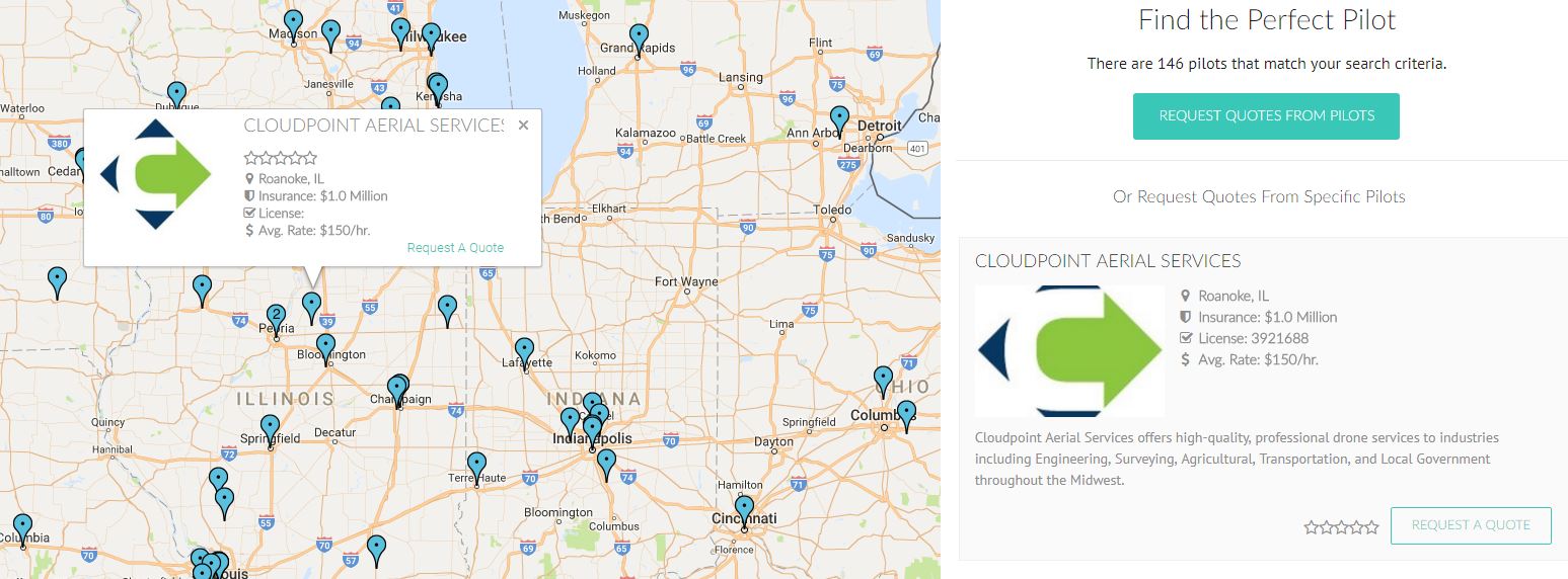
Using droners.io customers can easily create an account, post a job to the job board, and get quotes immediately.  Of course we also offer our customers to contact us directly for an immediate quote through our contact page, however droners provides another networking opportunity for people to reach out to us when they need professional drone mapping services.  With two (2) professional certified pilots on staff and growing, Cloudpoint Geographics is a fully insured mapping and geospatial service provider and able to deliver short turn-around times for drone imagery and topographic mapping projects.  Our recent entry into the Agriculture market is allowing us to offer value-added services to growers and researchers in a timely fashion.  For more information contact us at 877-377-8124 or visit our site.

Recap of the Township Highway Commissioners of Illinois Summer Seminar

THCOI.png

Each year, Township Highway Commissioners travel to Peoria, IL to attend the annual THCOI Summer Seminar. It's a great way for them to continue education about their role, as well as, connect with colleagues. This year Cloudpoint was eager to attend the seminar and discuss SignOps with the commissioners.

YouTubeChannelArt_2846x1152.jpg

SignOps is our in-house developed sign inventory program that allows organizations the ability to track location, detailed attributes, and maintenance records for each sign in their jurisdiction. Cloudpoint currently has a handful of Illinois townships that our using SignOps, and hopefully more will be on board after talking with Joe about the various capabilities while at the Cloudpoint booth.

Meet Honorary Roadie "Bessie" Sue. Bessie is a 50 year old Caterpillar motor grater that Cloudpoint client and Morton Township Highway Commissioner Greg Menold still operates!

Meet Honorary Roadie "Bessie" Sue. Bessie is a 50 year old Caterpillar motor grater that Cloudpoint client and Morton Township Highway Commissioner Greg Menold still operates!

All in all, it was a great seminar! Joe was able to meet with some existing clients as well as make several great new connections. If you want to take control of your sign inventory, contact us today for more information or a free demonstration of just how powerful SignOps is! And remember, for sign inventories there's only one way: SignOps!

Updating town-wide aerial imagery!

Recently Cloudpoint completed a drone flight of Roanoke, IL. The mighty burg of Roanoke is home to Cloudpoint HQ and often times is our guinea pig for implementing or testing new services. We set out to fly all of the town and capture detailed, crisp, clear imagery with our drone mapping capabilities. Although some of you instantly understand what a benefit this can be for a municipality, we thought it may be helpful to talk about the advantages to having Cloudpoint complete an aerial photography flight for your organization.

Here you can see the difference between the standard imagery basemap from Esri on the left and from Cloudpoint Aerial Services on the right. The updated imagery can assist in inspecting hard to reach areas like roofs and water towers.

Here you can see the difference between the standard imagery basemap from Esri on the left and from Cloudpoint Aerial Services on the right. The updated imagery can assist in inspecting hard to reach areas like roofs and water towers.

First of all, the most important benefit is the amazingly detailed imagery that is collected. Below you can see a side by side comparison between standard Esri ArcGIS imagery and the images that we collected.  The difference is clear.

Here is another side by side comparison between Esri's base imagery on the left and the imagery collected by Cloudpoint's drone. While the left image is pretty blurry, the updated imagery allows you to see inlets, road patching areas and much more d…

Here is another side by side comparison between Esri's base imagery on the left and the imagery collected by Cloudpoint's drone. While the left image is pretty blurry, the updated imagery allows you to see inlets, road patching areas and much more detail.

In addition to providing superior imagery, the timeline for deliverables is another plus for having Cloudpoint complete a flight of your city. Since we handle every step of the process in house, you can get your imagery brought into your GIS in days instead of months. With the ability to track projects from the sky, compare new and old imagery to look for unapproved parcel improvements which generates revenue, and the ability to locate manholes, valves, and inlets, a town-wide drone flight is a powerful tool for enhancing your GIS and mapping. 

Click here to view the Roanoke 2017 Ortho webmap

Although Cloudpoint can fly yearround, the best times for getting imagery is in the Fall after the leaves come down or in the early Spring after the snow melts and before vegetation starts to grow.

If you have any questions, please contact us at 877-377-8124 or you can visit www.cloudpointgeo.com/drones

Live from San Diego, it's the Esri User Conference!

Recently Joe traveled over 3,500 miles from Central Illinois to San Diego and back to attend the Esri User Conference. This was Joe's first UC and it was a great, albeit sometimes overwhelming, time! Joe was able to learn about the latest GIS services available from Esri, as well as connect with colleagues from around the globe. It was truly a worldwide conference, and he was able to connect with people from the US, England, Canada, Sweden, Chile, Russian, and many more countries.

Every year thousands of GIS professionals gather in San Diego, California for Esri's annual User Conference. It was once again held at the San Diego Convention Center.

Every year thousands of GIS professionals gather in San Diego, California for Esri's annual User Conference. It was once again held at the San Diego Convention Center.

Each day and night presented the opporunity to learn more and expand your understanding of GIS. By attending various classes on improving GIS use for public utilites, parcel management, drone mapping, and utilizing field applications to increase efficiency, Joe is excited to bring these new applications back to the office to get implimented. Below you can see Joe's photos from his trip.

Joe was able to take a lot of great information about up and coming GIS implementation and technology. In addition to the aforementioned info and tech updates, it instilled a desire to better serve our clients through the Esri platform and the Cloudpoint team! As always, if there's ever anything that Cloudpoint can do for your organization, please don't hesitate to contact us at 877-377-8124 or fill out our contact page.

Where. It Matters

Macon County SignOps, Signing Off

Over the past 3 months, Cloudpoint staff has been hard at work covering the hundreds of miles of paved roads that make up the Macon County Highway SignOps inventory. The primary team of Joe, Paul, Tyler, and Ken (our new intern!), inventoried and barcoded 7,218 signs, which involved logging assembly location, assembly type, sign type (with MUTCD code), sheeting type, manufacture date, install date, sign text, and noting any damage to the sign. 

At the beginning of this project, we updated a few features that really came in handy for field inventorying. One of those tools was the copy assembly feature. I cannot stress how great it was to be able to only have to create one assembly with opposite facing chevrons along a curve and "paste" them in place, as opposed to creating six or more around various curves! 

As with all of our field projects, Macon County graced us with great experiences and surpised us with natural beauty more times than once. Below you can see some of our favorite photos from the field.  If you have any questions about this project, or how SignOps can improve your organizations sign inventory, please contact us at 877-377-8124 and we'll be happy to help! You can also learn more at www.cloudpointgeo.com/signops


Stephenson & Junker receive Desktop GIS Associate awards!

Congratulations to Paul Stephenson and Matt Junker of Cloudpoint Geographics for receiving their ArcGIS Desktop Associate 10.5 certification.  This certificate is obtained by completing one of Esri's technical examinations which tests candidates experience applying ArcGIS concepts and processes to workflows.  Candidates must have two or more years of experience to be eligible for the award.  Paul and Matt have both displayed their proficient abilities in utilizing GIS software in the past and now have carved another 'notch in the belt' of their professional GIS career.  Well done Paul & Matt.

Educating folks about SignOps at the WCHA Summer Road School!

Earlier this week, Joe made a trip to the Chula Vista Resort in Wisconsin Dells, WI for the Wisconsin County Highway Association Summer Road School. The association hosts two road schools a year, one in the Summer and one in the Winter. These events allow County Highway Commissioners and County Highway Board Supervisors to get together to learn what issues are facing the state of Wisconsin, as well as learn about new solutions to existing issues.

Joe was able to meet with several new professionals and reconnect with a few existing clients. Cloudpoint was discussing the SignOps sign inventory system and how it can benefit the counties of Wisconsin. Want to learn more about how SignOps can take your sign inventory to the next level? Please don't hesitate to contact us at 877-377-8124 or visit www.cloudpointgeo.com/signops

Here are some rock formations of the Upper Dells of the Wisconsin River. The association scheduled both a golf outing and a boat tour for attendees. The boat tour was great and took place on a 109 year old 80+ foot vessel.

Here are some rock formations of the Upper Dells of the Wisconsin River. The association scheduled both a golf outing and a boat tour for attendees. The boat tour was great and took place on a 109 year old 80+ foot vessel.

We can't wait to see everyone again in the Dells for this Winter Road School in January!

A great week of APWA Conferences in Illinois and Wisconsin!

Jonathan and Joe have been traveling like it's the holidays lately. What's been keeping them busy is a combination of field work in Macon County, IL for a SignOps implementation and various parcel fabric projects. But here at Cloudpoint we love to get out and meet different GIS users and talk about solutions for problems and projects that they are undertaking. Over the past 8 days, Cloudpoint has traveled over 450 miles and been to two different American Public Works Association (APWA) conferences. Last week was the Illinois Chapter show in Peoria, IL and yesterday was the Wisconsin Chapter show in Madison, WI. Jonathan presented a talk about the use of UAV drones for mapping and how it can benefit local public works departments. These conferences make for longer days, but we wouldn't miss them! You can see a gallery of pictures below, including one of our hard hat winners from the Wisconsin show!

Want to learn more about Cloudpoint's various geospatial solutions and how they can take your GIS to the next level? Feel free to contact us at 877-377-8124 or visit www.cloudpointgeo.com for more information.


Be sure to signup for our newsletter HERE!

We're playing in Peoria: Cloudpoint partnering on a Pavement Rating Project for the City of Peoria, IL

Cloudpoint is excited to announce that we have partnered with DTS and Farnsworth Group for a pavement rating project for the City of Peoria! This project is quite extensive and entails driving every mile of City maintained roadways in a van equipped with laser scanning that collects and inventories every minute detail of the road. Once all the data is collected, the City will have a highly detailed record and rating for all of their roads. This data will be used for planning purposes which will allow them to budget and schedule upkeep and repairs for many years to come!

Here you see DTS's mobile asset collection van equipped with highly sensitive laser scanning equipment. This van will be the main data collection tool for the City of Peoria project.

Here you see DTS's mobile asset collection van equipped with highly sensitive laser scanning equipment. This van will be the main data collection tool for the City of Peoria project.

Growing the Fleet: Cloudpoint's slick new ride

Here you see three Cloudpoint branded vehicles of our fleet in the parking lot of our Roanoke, IL headquarters.

Here you see three Cloudpoint branded vehicles of our fleet in the parking lot of our Roanoke, IL headquarters.

With the number of field work projects increasing, and being well past the 200,000 mile mark on the current Honda Odyssey work van (Also known as Homer - get it? Because Homer wrote the Odyssey) we realized that we were going to be in the market for a new work vehicle. Well the stars aligned and the clouds parted, revealing a gorgeous "Cloudpoint blue" Dodge Caravan that was meant to be ours! Since expanding our fleet we are able to get field work done faster with two crews, and it allows us to travel with larger numbers in style. Be sure to snap a picture of the Cloudpoint vehicles and share it with us on our Facebook page, Twitter account, or Instagram feed.  We've grown fond of using minivans for work vehicles. With the ability to stow seats and utilize extra space for tools such as GPS units, shovels, probes, and more, we are dangerously close to optimizing our storage/occupancy ratio. This new work van is a great sign that we are growing and ready to take on more projects to assist our clients with their geospatial needs. Finally, you may think it's just a minivan, but to us it's a mega-van!